You Can Now Explore the Large Hadron Collider on Street View | Gizmodo


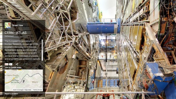
Google Street View is a great way to explore parts of the world you’ve never visited. And thanks to Google’s European team, it’s now one of the easiest ways to explore a facility you’re not exactly allowed to just stroll through whenever you want. Google’s panoramic cameras were given access to CERN’s Large Hadron Collider, letting anyone poke around the gigantic machinery and the facility’s endless network of tunnels.

CERN

Read: You Can Now Explore the Large Hadron Collider on Street View | Gizmodo.

Researchers build[ing] ‘Google Earth’ project for the ancient world | theguardian.com


A tool developed by researchers at Southampton University has indexed historic maps, photos and historic documents to provide a simple location search tool for the UK.

The Pelagios 3 project takes data from ancient Latin and Greek sources, which formed the basis of two previous Pelagios projects, and builds on it with documents and maps from Arabic sources, medieval European and Chinese maps, and seafaring charts from the 13th century, cross-linking them into one searchable database. 

Read the full story: Researchers build ‘Google Earth’ project for the ancient world | Technology | theguardian.com.

You Can Now Explore the Galapagos Islands With Google Street View | Gizmodo


The Galapagos is one of the most biodiverse places on the planet, and it was key in Charles Darwin’s findings in forming the the scientific argument of evolution. You may never get to travel to the volcanic archipelago in person, but now thanks to Google, you can explore it through 360-degree imagery on Street View.

The full story: You Can Now Explore the Galapagos Islands With Google Street View | Gizmodo.

You may also like: Darwin for a Day lets you play scientist, explore the Galapagos in Street View | Engadget

Do-It-Yourself GIS: 20 Free Tools & Data Sources for Creating Data Maps | Ellyssa Kroski – OEDB.org


The world of mapping and presenting data sets through geographical representations is no longer relegated to GIS librarians and highly trained technologists. New free and open source applications now make it possible to create complex and robust data visualizations in the form of maps that display statistics and poll results. Here’s a guide to 20 free applications and data sources.

via Do-It-Yourself GIS: 20 Free Tools & Data Sources for Creating Data Maps | Ellyssa Kroski – OEDB.org.

There are 6 data visualization tools listed and 14 sources for GIS mapping data.

Also see my list of Interactive Mapping Resources on The Modern MLIS. I have categorized resources as either digital libraries, visualization tools or stargazing maps. There is only a little overlap with Ellyssa’s list.

You may also like:  Ten Places to Find and Create Data Visualizations | FreeTech4Teachers

Mapping Creative Spaces Around The World | Co.Exist


If you’re looking for a creative space–a place to work that truly fosters collaboration, a place to learn new skills, a community of like-minded artists and entrepreneurs–you probably look on Yelp or do a Google search. That won’t yield much. These spaces are scattered across Yelp categories, and a Google search for “creative spaces” shows just a smattering of local spots. That’s what Berlin-based consulting studio ignore gravity discovered while researching creative spaces around the world.

So the studio pulled together data on hundreds of creative spaces and presented them in the Creative Space Explorer, a tool that lets users pinpoint creative spaces on a global map–and add their own. ” We define ‘creative space’ as an enviro that consciously is set up to trigger collaboration in a creative way,'” explains Max Krüger, one of the creators of Creative Space Explorer.

See the full article: Mapping Creative Spaces Around The World | Co.Exist | ideas + impact.

Mapping Creative Spaces Around The World | Co.Exist | ideas + impact